In 1918, the Forest Society purchased the first 521-acre tract on Mt. Kearsarge for conservation. Named Rollins Memorial Park in honor of Governor Frank West Rollins, a founding member of the Forest Society and its first president, that original conservation property was transferred to the State for the establishment of a State Forest in 1950.
That first acquisition inaugurated a tradition of the Forest Society stepping forward to protect land on Mt. Kearsarge “to be held in public trust”. It was followed by 1,500 acres in 1935, 585 acres in 1963, 900 acres in 1971. Of course, there have been bumps in the road – the Forest Society was not supportive of telecommunications towers on Mt. Kearsarge when they were first proposed. But over the course of a century, 9,500 acres on and around Mt. Kearsarge has been forever protected by the Forest Society, the state, surrounding towns and local land trusts.
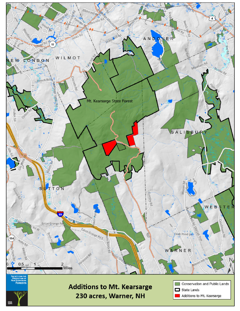
Now, we have the opportunity to acquire and protect some of the final inholdings at the top of Mt. Kearsarge. Two of the largest unprotected parcels behind the entrance gate of Mt. Kearsarge State Forest have been held in private ownership for decades. Together encompassing 230 acres, these properties include frontage along Kearsarge Mountain Road as it enters the park from Warner, and they include unique higher elevation habitat. Almost the entire property ranks as Tier 1 habitat in the NH Wildlife Action Plan. And, these properties have spectacular views – if not conserved, this land, even though behind the gates, could be developed as private camp lots.
The road access to high elevation at Mt. Kearsarge make it an especially beloved place. You can drive most of the way and still get out for a satisfying hike along the Rollins Trails and the 2,937 foot summit, with panoramic views from open ledges that include Smarts Mountain, Mt. Cardigan, Ragged Mountain, bookended by the distant Green and White Mountain ranges. To the southwest, views extend to Lake Sunapee and Mt. Sunapee and sometimes Mt. Monadnock and the Wapack Range or on to the Boston skyline. For the more intrepid, this is just a stop along the regional Sunapee-Ragged-Kearsarge Greenway (SRKG) trail.

The Forest Society has an agreement to purchase the 230 acres by the end of 2025. To do so, we needed to raise a total of $500,000 toward the purchase and costs. Thanks to the generosity of our supporters, 230 acres at the summit of Mt. Kearsarge are now conserved. Your support helped complete this important project and ensure these forests remain protected for generations to come. Stay tuned!
Please help us by making a gift to support the permanent conservation of the last large inholdings at the top of Mt. Kearsarge! Your gift will be part of a long tradition of citizen action to protect the icons of our state.

